
Water constitutes the primary element around which many human communities have settled since the Homo erectus, nomads who preferred to live near to rivers and valleys. Ancient civilisations converged around the rivers Tigris and Euphrates, bringing with them irrigated farming, cities, writing and consequently History.
Without doubt and as occurs in all areas, water (rivers, streams, sources, springs, etc.) has been the fundamental element that gave the Lecrin Valley its special nature and has determined the farming landscape and distribution of different human settlements.
Since prehistoric times, spaces such as the Lagoon of El Padul were especially significant, around which various farming communities existed. This lagoon existed as such until 18th century when it began to dry up with the construction of drainage or “mother” canals.
Various water constructions date back to Roman times, such as the pools of the Villa del Feche in Mondújar, the aqueducts of Zazar in Pinos and arches in Conchar, the baths of Bacamía in Dúrcal and the thermal baths of Chite and Melegís.
The Lagoon of El Padul is considered as one of the most important in the south-east of the Spanish peninsula both due to its biological richness and geological interest, as well as being a paleo-environmental referent of the Mediterranean region.
The Lagoon of el Padul is greatly significant as it is the only natural wetland in Granada province. As well as its unusual basic composition where bluegrass plants grow, it is also a constantly forming tectonic plate, two facts that are not very common in other lagoons studied, making it even more interesting.
Such that in 2006 the Official State Gazette number 47 of February 24 included the Lagoon of el Padul in the RAMSAR agreement (February 2 1971), regarding wetlands of international importance, especially as a habitat of aquatic birds.
In el Padul we can find different water courses, the first when entering the town from Granada via an access road from the motorway is the natural water spring in the area known as los Cahices. It is marked by the milestone that reads “Cuenca del Guadalfeo, Río Izbor”. This source where the water oozes is known in Padul as Fuentes Altas. From here follow the course to Fuentes Bajas or “Fuentes fajas”, as it is known locally. This water flow stops when it reaches one of the “mothers”, known as Madre del Quiti, which in turn joins the Madre Maestra (2), the main one born from the Ojo Oscuro [literally translated as the Dark Eye]. The “Mothers” are canals or ditches constructed between the 18th and 19th centuries to drain the primitive lagoon.
The Ojo Oscuro is the most representative source of the flooded area, with its presence favoured by the materials that form the entire small tectonic plate where they are located. These are comprised of detritic levels of low permeability and peat, which is extracted as soil substrate, fertiliser or soil corrector.
The Ojo Oscuro is accessed directly from the N-323 road from the coast towards Granada. As we approach El Padul, we can see a large density of giant reeds an area formerly flooded with water.
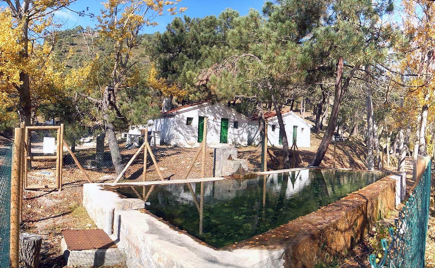
Next to this flooded area is one of the best known public baths in the town, the “alberca Palmones”, a deposit that collects water from a spring, where children and adults have bathed in the fresh water for many years, under the shadow of a large fig tree.
Following a narrow path skirting the nearby lands, we reach a bird-watching observation point, where with patience, we can see some of the 75 species spotted in this area.
Of the wader birds (group of long-legged birds that often inhabit the shorelines), which make up a large percentage of the wintering birdlife, it is possible to observe Dunlin (Calidris alpina), Common snipe (Gallinago gallinago), Black-tailed godwit (Limosa limosa) or Common sandpiper (Actitis hypoleucos).
Of the group of Herons, which are wading birds of variable size from medium to large, with long legs, neck and beak, we can see in this area the Great bittern (Botaurus stellaris), Little Bittern (Ixobrychus minutus), Night heron (Nycticorax nycticorax), Cattle egret (Bubulcus ibis), Squacco heron (Ardeola ralloide), Little egret (Egretta garzetta), Grey heron (Ardea cinerea), Purple heron (Ardea purpurea).
Other species linked to the water are Anatidae, split into two groups, swimming ducks, which are those that feed on the surface of the water and can take flight easily from the water without any run-up, unlike the group of diving ducks that feed mainly by diving and need a run-up to take flight.
The first group includes the mallard (Anas platyrhynchos) and the Common teal (Anas crecca) and of the group of diving ducks we can observe the Common pochard (Athya ferina) in this spot. We can also see the Little grebe (Tachybaptus ruficollis), similar species to the group of mallards but belonging to another family (Podicipedidae)
Other species represented in the wetlands are those belonging to the group of Water rails (rallus aquaticus), Moorhens (Galllinula chloropus) and Coots (Flucia atra), which are water birds that inhabit and hide among the tall vegetation, some experts in camouflage, such as the Roscón Europeo, Spotted crake (Porzana porzana), Polla de Agua or better known as the Moorhen (Gallinula chloropus), the so-called Purple swamp-hen (Porphyrio porphyrio) with its electric blue colour and the Common coot (Flucia atra).
Also, small wetland birds can be observed with restricted distribution within the Iberian peninsula, such as European bee-eater (Merops apiaster), Common kingfisher (Alcedo atthis), Robin (Erithacus rubecula), Savi’s warbler (Locustella lusciniodides), Blue throat (Luscinia svecica), Penduline tit (Remiz pendulinus) or Reed bunting (Emberiza schoeniclus).
The group of birds of prey is represented by the Marsh Harrier (Circus aeruginosus), Hen Harrier (Circus cyaneus), Montagu’s harrier (Circus pygargus), Sparrowhawk, Peregrine falcon, Merlin (Falco columbarius), Bonelli’s eagle (Hieraaetus fasciatus) (endangered species) and the Common kestrel (Falco tinnunculus).
Furthermore, the wetlands of Padul are home to a considerable number of species including the Southern Iberian painted frog, the Stripe-less tree frog, the Caspian pond turtle, grass snake and the viper. Indigenous freshwater crabs were abundant (Austropotamobius pallipes) but the introduction of the American red crab (Procambarus clarkii) displaced it due to its voracity.
With regard to the vegetation, the hydrogeophyte plants are very interesting in this floodland with plants such as cat’s tail (Typha), giant reeds (Phragmites), the common rush (Juncus effuses) and the white poplar (Populus alba). Also around the edges of the wetlands we can find vegetation typical of the Mediterranean area such as thyme, grasses, horse’s tail, etc.
To the south of the Lagoon we find various sources such as
“Los Molinos”, “Povedano” and “los Mísqueres”. The spring waters are drained by canals or “mothers” and the water outflow is carried by the so-called River Viejo or de la Laguna, flowing along the right edge of the River Grande or Dúrcal.
Taking the route that runs towards the mills, we find where the Aguadero Real was located or locally-known as the “first mills”. Following this route we find the source of “Los Molinos” where clear, fresh water flows. Close to this source is an old mill, which has been converted into rural accommodation. There are many springs that continue further down until they are considerable, such as the source of los Mísqueres, which is complicated to access.
Two kilometres from the route of the mills, is a track to the left that leads to the spring of Povedano. The water springs from the foot of a stone slope and immediately joins an irrigation channel.
The source of los Misqueres and the Spring of Povedano, give rise to the River Agia, where the Turbera de El Agia is found.
Following the route you reach an old bridge under which the Río de la Laguna passes, where it is possible to see all the underground water from the slopes.
As well as many natural springs, Padul has several fountains that lend character to the town, such as the Fountain of San Joaquín and Lavadero de Santa Ana [public washing place] or better known as the Fountain of los Cinco Caños [literally the fountain of Five Spouts], located on calle Lavadero. Fountain of el Calvario or better known as “las Cruces” on calle Real along which the old Road used to pass that linked Granada and the Alpujarra. Another characteristic fountain of the town and recently recovered was in this case, the Pilar de Maria Cabeza, on calle Real, named by a local resident. The water trough of the Casa Grande was also restored, an emblematic building of El Padul.

Following the old coast road we reach Dúrcal, where the difficult orography is immediately visible caused by the different gulleys along which the river flows.
At the entrance to Dúrcal , along the old national road, passing the stone bridge, we come across a tree-lined area known as Pilar del Mono, a popular stop-off for travellers coming from the coast in olden days and today where we can see people waiting to fill litre upon litre of water from this fountain.
Dropping down towards the river and crossing the old bridge we start to climb up along the old road that follows the cutting of las Fuentes ravine and where the waters are channelled in acequias or irrigation channels that drive various mills. The public wash houses are located at this point and nearby the remains of a Roman villa have been uncovered.
If we climb along different routes that lead to the Sierra de Dúrcal, we can see its precipitous nature, with the River Dúrcal born at the feet of los Tajos Altos and the Tozal del Cartujo at a height of 3152 metres, with climatic conditions of strong sun, extreme temperatures, strong winds, summer drought of Mediterranean latitudes and the presence of snow over eight months of the year, which impedes the development of woody species and gives a high number of endemic species. Borreguiles grow in this area, a name given to the mountain pastures.
From this River Dúrcal, formerly Guadalquivir or River Grande in the books of Apeo, the barranco de las Fuentes, the River of la Laguna, the barranco del Alcázar are tributaries into the Basin of Cijancos, the River of las Albuñuelas (Río Santo) and the River Torrente. All converging to form the River Ízbor.
This river descends from the Puerto del Cura along a ravine until the Padul-Durcal fault breaks, sweeping away rocks to create a wider valley. In this flatter area where the river runs there is a multitude of wells where you can take a dip and plenty of picnic spots along the way.
As we continue to descend along the river bank we find The route of “las Fuentes” which starts at the old bridge and on the right hand side is an Educational Farm in what was the Molino de Doña Juana and the old light factory.
As the river flows along the lowest part we reach los Baños. Which can be accessed by vehicle, taking the route next to the hermitage of San Blas, where a placard indicates “Medicinal Waters”.
Following this tarmac route, although part remains unfinished, we reach the river. This area is highlighted due to the Baths of Urquízar, baths where people have visited since Roman times to relax, take care of their skin and try to get rid of kidney stones, submerging in pools full of mineral water, where they can reach 25 degrees temperature or drinking from the spring tucked in the rocky walls. Here we can see the waterfall of Cijancos where this gorge joins the river.
Close to the Baths of Urquízar are the Baths of Bacamía, of similar characteristics but in a more hidden area and formed by a single pool.
If we continue down the path we reach the Cave of los Riscos. It is a large cave in a beautiful spot, as the river passes just a few meters from the entrance. Formed by a material called travertine, which is a porous or crystalline mineral of calcium carbonate, deposited in layers by hot or cold water springs.
Inside the cavity we can see different forms such as stalactites that hang from the roof and the stalagmites that rise from the floor upwards. There are other structures such as columns, formed by the joining of stalactites and stalagmites. Another curious formation are the gour pools, a type of pool that is formed by dissolution. Close to the Cave of los Riscos is the mouth of the stream from the large pool or Bacamia, forming a small waterfall and crossed by a gallery, allowing you to cross from one side of the waterfall to another.
Throughout the journey there is a wide diversity of vegetation, formed by tree species such as oaks, black poplars and willows, covered with ivy that creeps up their trunks and another characteristic species such as oleander.
The fauna associated with riverside woodland that we can find in this area are the Kingfisher, Wagtail, Meadow pipit and the House martin etc.
Although often overlooked due to their size, macroinvertebrates are essential fauna in river life as they are the first bioindicators of contamination in the river, ecological conditions and water quality. Therefore studying them is highly significant for the maintenance and prevention of disturbance in rivers.
The old irrigation channel of Márgena on the left bank takes its name from the old mill and carries water for almost two kilometres before irrigating. Below the irrigation channel of Marchena runs along the right side, a little lower than that of los Llanos or Padul. The irrigation channel of Marchena branches off into two with one for Cozvijar and other for Dúrcal four days of the week and Padul three days of the week.

The municipal area of Nigüelas is located at the foot of Sierra Nevada, where the River Torrente starts close to the Cerro del Caballo in the area known as the Rinconada or Chorrerón. It is simply a stream for many who are unfamiliar with it, however, it can be an impetuous river capable of halting hundreds of carriages on its river banks, ministers such as Natalio Rivas or a king such as Alfonso XII.
Close to the source of the river, taking the route to the right are the prairies of Isidora where there is another natural source.
There are natural springs scattered across the gulleys formed in the sierra, but many are inaccessible. We can find the springs known as “Fuente Mari López”, “Fuente la Cueva”, “Fuente el Sabuco”, “Fuente el Trompa”, “Fuente Fría”, “Fuente del Malagueño”, the latter bordering the neighbouring village of Acequias. All known by the locals. There are also drinking water springs such as that of “Pecho la Oveja”, which supplies the village and when it runs dry is joined to another spring on the slope of las Yeseras.
The existence of natural springs in this area was considerable, but gradually the flow reduced due to the increased planting of pine trees, which require a vast amount of water.
In the town itself we can see in the Plaza de la Iglesia [church square] a water deposit and the fountain with its numerous spouts in front of the church, an ancient water deposit that was used up until 1970s.
We can also see the irrigation channel of la Pavilla, named after the young couples who used to "pelar la pava" or seduce each other in the shade of the birches. The same branches formed garlands that the youngsters traditionally courted with on the night of Easter Saturday.
The irrigation water is taken above the village, just below the power station where we can find a reservoir in the River Torrente, which starts the irrigation channel of la Moranja that splits into three. One part for Mondújar and Acequias, another for Dúrcal and another for Nigüelas. The flow from this slope of Torrente is increased with the irrigation channel of los Hechos that collects the water from the peaks of the Sierra Nevada.

The waters of the River of la Laguna flow through Cozvíjar from Padul, originating from the Madre Maestra. In the past there were up to five flour mills and today we can see some still standing and restored as houses. In this river there was the first electric power station of the Valley, then a factory with more power was built, located at the convergence of this river with that of Dúrcal, in this way it used the hydraulic force of part of stream of el Alcázar, the River of la Laguna and the River Dúrcal.
Caves can be found along the river that have been inhabited since the Palaeolithic Age. Part of the flow is diverted from the new Irrigation Channel of Lecrin and the old Royal Irrigation Channel of Cónchar.
No sooner than entering the village of Cónchar and following the road down we find a small stream, crossed by a bridge, a pleasant spot to take a rest, as just a few minutes away is the Fuente Palomares, where it is common to see the locals taking the water. In the past the place was frequented by the womenfolk of the village as the public wash house was located there.
The stream of el Alcázar passes through this village, which starts in the rambla de Cijancos, a little under the cortijo La Venta, in the area known as La Canal, flowing into the river Dúrcal, opposite the Baths of Urquízar.
The fuente del Lino was the fountain that was used to fill the water deposits and where they used to sew linen and then esparto, a tradition deeply rooted in this village and that generated most income for the locals.
The municipal area of Albuñuelas is rich in water sources and streams that arise from the mountains (Sierra de las Albuñuelas and Sierra de los Guájares), leading to the formation of numerous slopes where the natural spring waters flow such as “Fuente del Barranco del Agua”, “Fuente del Cañuelo”, that originated in the place with the same name, the “Fuente la Teja” that originated in the place known as el Balate, etc.
The dominant watercourse in this area is that of the Rio Santo or River of las Albuñuelas which has carved out a large bed or valley taking advantage of the tectonics. This river originates on the plateau that runs in los Becardes, forms a gully that together with others forms the river. The Luna gully runs parallel to join this river below the village of Saleres. This river has a permanent flow along which some believe is called Río Santo or holy river due to its quality, others think that it is called this in reference to the hermit communities that used to live in the caves tucked in the walls along its flow. There are routes following the river where it is possible to practice abseiling. On its left side is the gorge of la Fuente de los Siete Años. This spring was highlighted by the professor and naturalist of Albuñuelas, Mr. José Mariano Vallejo in his publication Tratado de las Aguas. On studying the intermittent sources he writes: “As a child I saw a source of this nature, five leguas1 from Granada, in the jurisdiction of Saleres and in a place called viñas de Orbe. It was called the Fuente de Siete Años, doubtless due to some eruption or intermittence that would last for such a period. The news that I have been able to glean is insufficient to establish the order of these periods. The current state is that after not flowing for three years, water began to flow this year 1830.”
Four irrigation channels run from the river of las Albuñuelas, two irrigate the farmland of Albuñuelas, the irrigation channel of el Molino aceitero [olive oil mill] is on the left and the main one and the irrigation channel of la Almadraba. Underneath is the irrigation channel of Restábal and Saleres and on the other said is the irrigation channel shared by Albuñuelas and Saleres.

The thermal spring of El Baño is located 2 km before reaching Melegís, indicated by a sign pointing in that direction.
Once you take the route that leads from the main road, follow it down and on reaching the cemetery take the path to the right. These thermal baths containing water with healing properties, have been remodelled and an enclosed area has been constructed with two pools.
From the cemetery you can enjoy a magnificent panoramic view of some of the Valley’s villages as well as Beznar reservoir, which can be reached from here, taking the path on the left passing the cemetery.
Following the road we reach Melegís, once in the village turn right and we encounter the River Torrente. It is worth looking for the irrigation channels of el Burgo and of los Arcos and following them on a pretty walk that runs between the citrus groves and overlooked by the castle of Murchas.
Next to the convergence of the Rivers Albuñuelas and Dúrcal, at the foot of los Canjorros Hill we find Restábal. To the east of the village is the Alos gorge where we can see cavernous zones that have been worn away by the water in the limestone. From the peak of los Canjorros Hill which is accessed by las Arenas gorge, you can enjoy the panoramic view of the Valley and the shores of Beznar reservoir.
Saleres is located on the left side of the River Santo, which originates in the Sierra de las Albuñuelas and as we walk through it gives way to a lush valley, formed especially by vegetation comprised of lianas, grasses and fig trees. As we drop through this area we can find more dense vegetation formed by oaks, willows, etc.
In the Sierra, which is accessed via a path that leaves the town, is the spring fuente de los Siete Años, today almost dry and the Fuente del Olivar de Santalla.

Between the River Torrente and the Pleito gorge we find the village of Acequias. Its sierra is home to several water sources that supply the village. It is clear that this village is rich in water sources and natural springs. Some of these springs include the Fuente de Rica, Fuente la Víbora, Fuente Solana, Fuente el Sabuco, Fuentes Frías and even the existence of small springs that originate next to the gorge, which remain unnamed.
Passing the boundary of the Pleito gorge is Mondújar which shares the waters of the River Torrente with Acequias and has its own irrigation channel of la Sierra that originates from the fuente Alta.
Murchas is located between the Rivers Torrente and Dúrcal with this area forming one of the most lush citrus and olive groves. Irrigated by the new irrigation canal of Lecrín. Formerly Murchas and Lojuela were irrigated with the waters of the galleries of the Torrente, all hydraulic engineering works in passageways and earth tunnels.
Chite and Talará have always depended on the springs of the Torrente and Pleito from where the Royal irrigation channel was taken, these days the new canal lends to the lushness of the plantations. For many years, two other channels irrigated the land and were known as those of el Baño and el Moginar taken from the Arrendate gorge. Wells were also used to irrigate the farms.
The village of Béznar crossed by three gorges that end in the reservoir. Along the road from Talará we find the Calavera gorge, which creates impressive cuts when it enters the reservoir close to the school. The Canales gorge is in the middle of the village and the Quete gorge in the direction of Motril. We find various fountains in the area and a pretty public wash house at the fuente del Chorreón.
The reservoir is reached by the old road to the Lower Quarter, where there is a pleasant picnic area. At Béznar reservoir we can observe different species of Ciprinids such as chub, carp, barb and Centrarquids such as the black-bass or better known perch.

Along the road from Restábal or along that which runs along the wall of the Beznar reservoir we reach Pinos del Valle, located on the side of the Chinchirina mountain. Pinos has numerous sources that irrigate the fertile lands planted with olive trees, citrus and fruit groves.
On entering the Barrio Alto and close to the sports centre, starting to climb up to the hermitage of Cristo del Zapato, we find public washhouses with stones polished from years of rubbing with soap. Just a few meters away are the spouts of the “Fuente el Juncal”, water not only to quench thirst but years ago was used to wash the body and soul and make the children and lands of Pinos fruitful. The cardinal understood its power and blessed it with the cross that acts as a guide to the fountain, to the Chinchirina and to the hermitage of Santo Cristo del Zapato.
There is a beautiful pillar in the portico of the church of San Sebastián, on its basin there are three lions that spout clear and refreshing water.
Close to las Eras quarter we can find the “Fuente del Olivo”, in the area known as the Molino Quemado, literally the Burnt Mill. The waters of this spring do not have the power to move a millstone but they are an essential element in an oil mill.
In the Lower Barrio the facade of the oil mill is lined with a dozen spouts that supplied this quarter, close to another public washhouse, from the time of prefabricated cement. The waters from this fountain are stored nearby in a deposit for irrigation.
Another well-known spring, located two kilometres from the village, following the road towards Guájar Faragüit, is the spring of Zaza. At this point we can see a group of mills and an aqueduct on the old road to the Coast. The waters flow in the surrounding area occupied by wetland vegetation.
In the direction of Motril, we find los Acebuches annex to Ízbor. Close by the River Grande passes through a deep gorge cut through the rock which takes the name of River Izbor. In los Acebuches, next to the tunnel and Izbor bridge, between limestones and the shade of a fig tree, is the “fuente Tío López”, whose waters irrigate the fields. On the other side of the tunnel, the fuente del Miriñaque which has quenched much thirst during the interminable journeys between Granada and Motril by road.
From the Hundidero ravine are three irrigation channels that irrigate the area of Ízbor and take the names Altera, Pinar and Vega. We find various springs in the area and the canal that feeds the power station of Vélez Benaudalla.
1 Old measurement of distance - one legua is equivalent to 5572m
Autora: María José Morales Romero